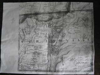
Springville Township

I came across this photocopy of a map of Springville Township from 1872. I am sure that this is completely uninteresting to anybody who doesn't live here, but I spent hours looking at it. The map mostly shows which family lived on each farm. Our farm, which is just to the west of the town of Springville, was owned by a J Koonts. I saw an earlier map once from 1858, when it was owned by a family named Meacham. The Meachams didn't disappear off the face of the map, they just moved a few miles to the south west. A lot of the family names on these farms are still in the area, if not on the same farms. The map also shows the location of all the supporting industries at the time, like blacksmith shops, sawmills, feed mills, etc. It is impressive how quickly this information can be forgotten. I always suspected that there was another farm just to the south of ours on what used to be the Wilkes-Barre Owego turnpike. Now the turnpike is the lane from my house to barn, and after that an abandoned road through the woods. The map supports that there was. The map is full of roads that existed in the horse drawn days but have since been abandoned.

3 Comments:
Our town office as the original maps. It is fascinating to look at the old ones. Merry Christmas & Happy New Years!
-Walter & Family
Sugar Mountain Farm
in Vermont
I can spend hours looking at maps. A used bookstore I know of is supposed to have an old, old map of the county where my woods are. I periodically send and email to the store to see if they've found the map in their inventory. The trouble is, when they finally do, I'm sure they'll want too much for it since they know I am an eager buyer.
Did you know you can go to the courthouse and research your land back to William Penn? And it's free. I have a map just like yours that hangs in my house here in Springville....I'd have to take a look and see what year it is from.
Post a Comment
<< Home